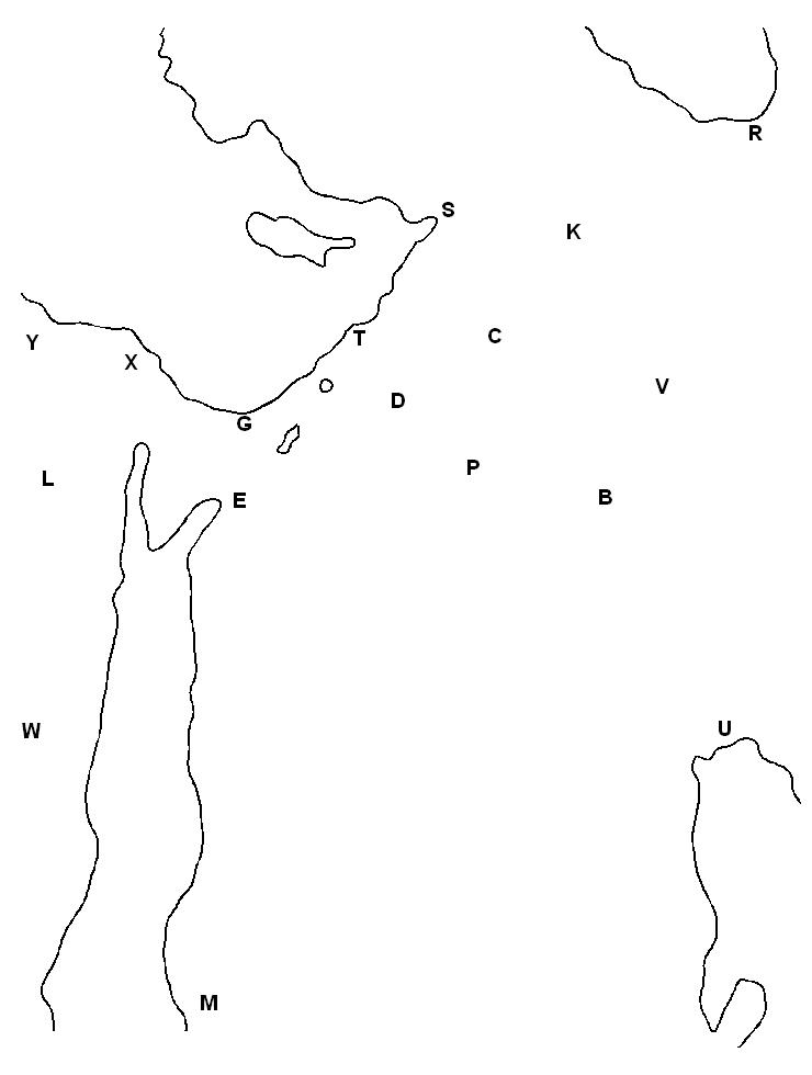
Geography for Solomon and the Queen of Sheba (1Ki 9:26-10:13; 2Ch 8:17-9:12)
Click the image when you want to Print the (.jpg graphic) coloring page or Save As for your own file (to color in your computer's drawing app, etc). Click here for a (.txt file) version of these instructions.
Blue - Start by indicating the bodies of water, so that your eyes can tell which are the land parts. It's not necessary to color the seas all in, but just to trace a blue line around on the seaside of the shorelines. Also dot in the tiny lake near (T)yre: the Sea of Galilee; and the longer one below it near (G)aza: the Dead Sea.
Blue - Put in the rivers like this:
The Jordan river: Draw a short, straight line between the Sea of Galilee and the Dead Sea.
The Nile river: Draw a line from Ale(X)andria to Crocodi(L)opolis to As(W)an.
The Tigris river: Draw a line from (K)ars to Nine(V)eh to (U)r.
The Euphrates river: Draw a line from (K)ars to (C)archemish to (B)abylon to (U)r.
`Note: Kars is situated below Mount Ararat, where Noah's Ark is supposed to have come to rest. Carchemish= Josiah/ Babylonia. Alexandria= Agora, Crocodilopolis= ?, Aswan= Ramses Abu Simbel.
Green - Mark off the section of land where trees and crops grow best: this large area is called the "Fertile Crescent" because of its shape (kind of). Draw a line from C(Y)rene to As(W)an to (E)zion-Geber to (P)almyra to (U)r to (R)ize to Tar(S)us. When God called Abraham out of his home town of (U)r, Abraham naturally followed the curve of the Crescent westward in his search, and stayed for a time in Haran, in about the middle of its widest part.
Solomon built up and expanded the city of (P)almyra, which was at that time a small Persian village called Tadmor (1Ki 9:18, 2Ch 8:4), because even though (or since) it was on the edge of the wilderness, Solomon could see that most of the trade that traversed the Fertile Crescent would find it as a crossroads more convenient than those which existed farther north.
Purple - Locate the kingdom of Israel by drawing a line from (G)aza to (E)zion-Geber to (D)amascus to (T)yre. This was as far as the kingdom ever reached, and it was broken up right after Solomon died, but the kings of Judah kept some ships in the port at Ezion-Geber up through the time of Jehosaphat, although they appear not to have been kept up very well (1Ki 22:48).
Solomon had the ships specially built there on the south side of the land by his expert sailor friend King Hiram of (T)yre, because there wasn't any other way to get ships there except to go clear around unknown Africa, and Solomon wanted to do some exploring to see what was out there.
Brown - Note the camel caravans' route by drawing a line across the desert from (U)r to (E)zion-Geber. This is the way that the 3 wise men from the east took, because they were in a hurry and following the star. Only camels, the "ships of the desert", could be used to cross this area of the Arabian desert (where Lawrence of Arabia would later hang out), but this shortcut allowed a higher volume of trade (more round trips per year) for those who could manage it.
Orange - Locate the queendom of Sheba by drawing a cap over (M)ecca and then downward in parallel to the east of the coastline until the bottom of the page. She ruled over the western seaboard of Arabia from its base at the entrance to the Red Sea up to perhaps as far as this oasis city with its traditions of Abraham and Ishmael. This puts them across the Red Sea from the presumed lands of Ophir, somewhere in Africa, with whose ancestors they appear to have been connected (Gen 10:28-29), and where the legendary King Solomon's mines lay. Here they were in a good position to regulate trading and to venture out into the wider oceans, as later was done when the large island of Madagascar off the east coast of Africa was turned into a new world pirate stronghold.